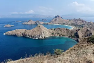
Komodo National Park Is an Official Land-and-Sea Conservation Area
Indonesia’s official conservation atlas and UNESCO documentation both place Komodo National Park in a land-and-sea protected-area framework, with zoning designed for the whole park.
Editor: Mursyid Sonsang
· Event date: · 3 min read Updated
Labuan Bajo — Komodo National Park is managed as a single conservation area that includes both land and sea, according to Indonesia’s Ministry of Environment and Forestry and UNESCO. Official and institutional sources also show that the park has long been recognised as a protected area with a marine component, but the exact figure used for the park’s current area depends on which legal and reference document is cited.
The ministry’s Atlas Monitoring Terumbu Karang di Kawasan Konservasi 2015–2021 lists Komodo National Park as an example of a conservation unit whose management mandate covers both land and sea. UNESCO likewise says the park is managed by Indonesia’s central government and describes its protected-area history as including an expansion in 1984 to add marine area and additional terrestrial zones.
What the official classification says
The atlas groups Indonesia’s conservation areas by the relationship between management mandate, land and water. In that framework, Komodo National Park appears in the category for areas where the mandate is located in both land and sea.
That classification is about management scope, not just geography. It supports the basic point that Komodo National Park should not be described as only a land reserve or only a marine park.
UNESCO’s documentation on the World Heritage site states that the park was first declared in 1980 and later extended in 1984 to 219,322 hectares, with the expansion including a marine area and additional terrestrial zones.
A separate academic and institutional source on the park states that the zoning system for Komodo National Park covers both terrestrial and marine areas, and that a single zoning system was designed for the entire park.
Why the land-sea relationship matters
The land-sea structure matters because it affects how conservation, tourism and use rules are organised. The park is not managed as a simple island-only protected area, and its zoning framework has historically included different types of terrestrial and marine zones.
For readers, the practical takeaway is that Komodo National Park is best understood as a combined land-and-sea conservation unit. That is consistent with the official atlas, UNESCO’s site history and the park’s zoning literature.
Context
The ministry atlas was issued by the Directorate General of Conservation of Natural Resources and Ecosystems and covers coral-reef monitoring from 2015 to 2021. Its purpose is broader than Komodo alone, but it is useful because it places the park inside a national typology of conservation areas with both land and sea mandates.
UNESCO’s site page adds historical context: the area first received national park status in 1980 and was expanded in 1984 to include a larger protected complex.
For publishing, the safest formulation is that Komodo National Park is an officially recognised land-and-sea conservation area, while detailed boundaries and zoning should be checked against the latest legal and cartographic instruments.
Sources
Read next
More on this story
Wildlife
Are Komodo dragons venomous? What the science says
Komodo dragons are venomous lizards. Research has identified venom glands and toxins that help them weaken prey by lowering blood pressure and prevent…
Latest in Komodo National Park

Today’s top story

Related