Sabu Raijua beyond Kelabba Madja: hills, beaches and village culture
Sabu Raijua in East Nusa Tenggara offers more than Kelabba Madja, combining traditional villages, caves, beaches, limestone hills and salt ponds.
Editor: Mursyid Sonsang
· Event date: · 6 min read Updated
Labuan Bajo — Sabu, a small island in East Nusa Tenggara, offers far more than its best-known Kelabba Madja landscape, with a mix of traditional villages, caves, beaches, limestone hills and salt ponds spread across Sabu Raijua regency.
Sabu, also known as Savu or Sawu, forms part of Sabu Raijua, a regency comprising several islands in the south of the province between the Savu Sea and the Indian Ocean, according to local government investment profiles and topography notes.
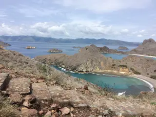
The regency government describes the area as dominated by limestone hills with average slopes around 45 degrees and peaks generally below 250 metres, and notes that most of the territory lies at 0–100 metres above sea level. These conditions mean travel times may be longer than straight-line distances suggest, particularly away from the main roads.
Access to Sabu
According to a regency investment profile, Sabu Raijua is served by Tardamu Airport, classified as a public airport of class III. The document states that the runway is used by small aircraft and records scheduled services linking Sabu with Kupang and other towns in East Nusa Tenggara.
A separate tourism feature on Sabu notes that the quickest access is by air from Kupang’s El Tari airport, with flights operated by Susi Air to Tardamu Airport, while many residents and visitors use the Express Cantika fast boat or ferry services for sea crossings between Kupang and Sabu. The same report describes crossings taking several hours and mentions alternative ferry options, but travellers are advised to confirm current routes, tickets and schedules directly with operators.
Start near Seba and the airport
Sabu’s cultural sites near the main town and airport provide a practical first layer for a visit. Indozone Travel places Kampung Adat Namata in Raeloro village, Sabu Barat, around 2.5 kilometres or about 10 minutes from Tardamu Airport, and describes rows of traditional houses, including structures used to keep heritage objects.
Kata Omed’s travel guide also highlights Namata as a village where visitors can learn about local history, see traditional rituals and weaving, and try Sabu traditional clothing. The guide presents the settlement as an important centre of local culture and belief.
A second cultural destination identified by Kata Omed is Kampung Adat Kujiratu in Kujiratu village, Sabu Timur, characterised by traditional houses, stone structures and sacred sites where customary practices remain preserved.
For a nature stop, the same guide lists Gua Lie Mabala in Eimau village, Sabu Tengah, reachable in about 20–30 minutes by road from Seba. It portrays the cave as naturally lit from openings above and around the entrance, attracting visitors for exploration and photography.
Several practical figures emerge from the travel reports:
- Tardamu Airport to Kampung Adat Namata: about 2.5 kilometres, or roughly 10 minutes by road.
- Seba to Gua Lie Mabala: around 20–30 minutes by road.
- Seba to Kelabba Madja: about 28 kilometres, according to Indozone Travel.
- Sabu Raijua’s average elevation: generally 0–100 metres above sea level, according to regency profiles.
Hills, beaches and salt landscapes
Kelabba Madja remains Sabu’s signature attraction. The NTT provincial tourism information centre presents Kelabba Madja as a multicoloured canyon-like landscape with layered cliffs and hills in shades resembling a rainbow, and describes it as a “Grand Canyon” of Indonesia. Indozone Travel similarly notes layered hills and valleys in maroon, pink, brown and grey, while Kata Omed emphasises tall, curved rock formations.
Indozone Travel reports that Kelabba Madja lies about 28 kilometres from Seba with road access described as relatively good. A separate travel article places Bukit Salju, a pale limestone hill, in Ledeae village, Hawu Mehara district, about 29 kilometres from Seba and roughly 45 minutes by road. Provincial tourism coverage also introduces Bukit Salju as a bright, chalky hill near the south coast that has become a popular viewpoint.
Kata Omed lists Bukit Lede Pemulu as another open hill facing the sea, used by visitors to watch sunrise and sunset, while advising that those who intend to camp seek permission from local community representatives.
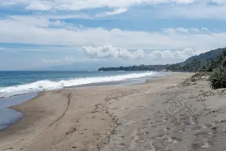
Beyond the hills, Kata Omed’s guide names beaches including Rae Mea, Kepo, Hailape, Koloudju, Cemara Jiwuwu, Cemara Nyiuwudu and Ege, along with cultural or landmark sites such as Tugu Mone Mola, Istana Teni Hawu and the salt ponds of Kampung Lobo Bali. A separate local media feature on Pantai Rae Mea describes the beach as a distinctive photo spot with reddish sand and notes that the location can be reached in roughly 50 minutes or about 28 kilometres by road from the airport area.
Plan with local confirmation
The available government and tourism reporting shows Sabu as a destination for mixed cultural and landscape travel, but they do not function as a complete, real-time directory of transport and visitor services. Travellers are encouraged to verify current flight and sea-service schedules, booking options and local transport in advance, particularly during peak seasons or when planning multi-stop itineraries.
Visitors should also confirm local arrangements for customary villages, caves and remote beaches, including whether cultural visits require prior permission, whether guides are recommended, and what facilities exist at each site, given the island’s limestone terrain and limited infrastructure.
Context
Sabu forms part of Sabu Raijua regency, an autonomous local government area established in the late 2000s after separation from Kupang regency, according to regional planning and investment documents. The regency’s topography and investment profiles describe an area separated from nearby islands by the Savu Sea and the Indian Ocean and note a historic reliance on sea links alongside the development of the Tardamu Airport for air connectivity.
Recent provincial and national travel features have focused on Kelabba Madja’s coloured cliffs, but destination lists from Indozone Travel, Kata Omed and other outlets show that Sabu’s offer extends well beyond its headline canyon to include cultural villages, caves, beaches, limestone viewpoints and traditional salt landscapes.
Sources
- Indozone Travel – Beragam Destinasi Unggulan Pulau Sabu NTT yang Memanjakan Mata
- Kata Omed – 20 Tempat Wisata Di Pulau Sabu NTT Yang Bisa Dikunjungi
- Kabupaten Sabu Raijua – Topografi
- Victory News – Pantai Rae Mea di Kabupaten Sabu Raijua, Spot Foto Bertema Alam Yang Unik
- SINDOnews – Yuk! Kunjungi Pulau Sabu, Surga Wisata di Tanah Timor
- Rancangan Akhir RPJPD Kabupaten Sabu Raijua (PDF)
Read next
More on this story
Flores & Beyond
Wae Rebo to Close 2–3 October for Customary Family Ceremony
Tourist visits to Wae Rebo in Manggarai, East Nusa Tenggara, will be suspended on 2–3 October 2026 for a customary family ceremony, according to local…
Latest in Travel & Access
Today’s top story

Related