Lewotobi Laki-laki Erupts on 28 August, Ash Rises 1 Kilometre
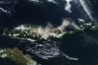
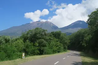
Mount Lewotobi Laki-laki in East Flores erupted on the morning of 28 August 2026, sending a one-kilometre-high ash column to the southwest and west.
Editor: Mursyid Sonsang
· Event date: · 3 min read
East Flores — — Mount Lewotobi Laki-laki in East Flores, East Nusa Tenggara, erupted on Friday morning, 28 August 2026, sending a thick column of volcanic ash about one kilometre above its summit and drifting to the southwest and west, according to Indonesia’s Geological Agency at the Ministry of Energy and Mineral Resources.
Geological Agency head Lana Saria said the eruption began at 7:35 a.m. local time and was recorded on a seismogram with a maximum amplitude of 14.8 millimetres and a duration of about six minutes and four seconds, as reported by national media citing her official statement.
The eruption did not trigger a change in the volcano’s alert status.
Mount Lewotobi Laki-laki remains at Level III (Alert) on Indonesia’s four-tier volcanic alert scale, and authorities are maintaining a five-kilometre exclusion zone around the eruption centre for residents, visitors and tourists, according to the Geological Agency and monitoring summaries based on PVMBG and MAGMA Indonesia data.
Safety guidance for nearby communities
In her statement, Saria urged people living near the volcano to wear masks or cover their noses and mouths to limit exposure to volcanic ash, which can irritate or damage the respiratory system.
The Geological Agency also asked residents to stay alert for rain-triggered lahars — volcanic mudflows generated when ash is remobilised by heavy rain — in rivers whose headwaters rise on the volcano’s flanks.
Areas identified as particularly vulnerable to lahar flows during periods of intense rainfall include Dulipali, Padang Pasir, Nobo, Nurabelen, Klatanlo, Hokeng Jaya, Boru and Nawakote, according to guidance from the volcano observation network.
Officials have advised residents to remain calm, rely on information from local governments and the Lewotobi Laki-laki monitoring post, and avoid unverified reports circulating on social media or messaging platforms.
The Center for Volcanology and Geological Hazard Mitigation (PVMBG) is coordinating with the East Nusa Tenggara disaster management agency and local authorities on ongoing monitoring and public warnings concerning Lewotobi Laki-laki’s activity.
Key figures from the 28 August eruption
- Eruption time: 7:35 a.m. WITA (local time) on Friday, 28 August 2026
- Duration: approximately six minutes and four seconds
- Ash column height: about one kilometre (1,000 metres) above the summit
- Seismogram maximum amplitude: 14.8 millimetres
- Exclusion zone: five kilometres from the eruption centre for residents and tourists
Ongoing activity and hazard context
The 28 August eruption came during a period of heightened activity at Lewotobi Laki-laki in August 2026, when the volcano produced multiple eruptions over several days.
Monitoring reports drawing on PVMBG’s MAGMA Indonesia platform noted continuing eruptions and maintained the Level III status through late August, warning the public to stay at least five kilometres away from the crater.
PVMBG and the Geological Agency have emphasised that, while recent eruptions including the 28 August event were relatively small in scale, repeated ash emissions, lahar potential and the possibility of further explosive activity justify strict adherence to the current exclusion zone and civil protection measures.
Sources
Next story
Muhammadiyah EMT treats 2,222 Flores earthquake survivors
Muhammadiyah’s Emergency Medical Team treated 2,222 earthquake survivors at its WHO-standard field hospital in Flores between 17 and 28 August 2026, a…
Related