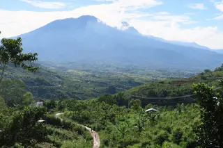
Anak Ranakah Raised to Level II Alert After Flores Quakes
Indonesia’s volcanology agency raised Mount Anak Ranakah in Manggarai, Flores, to Level II (Alert) at 23:00 WITA on 1 September 2026 after a sharp rise in volcanic and tectonic earthquakes.
Editor: Mursyid Sonsang
· Event date: · 4 min read
Labuan Bajo — — Indonesian authorities have raised Mount Anak Ranakah in Manggarai, Flores, from Level I (Normal) to Level II (Alert) as of 23:00 WITA on 1 September 2026, following a marked increase in seismic activity after the 15 August Flores earthquake, according to the Geological Agency’s volcanology centre.
Pusat Vulkanologi dan Mitigasi Bencana Geologi (PVMBG), part of the Geological Agency, reported that monitoring in August and early September showed a sharp rise in deep volcanic and tectonic earthquakes around Anak Ranakah. Local media citing PVMBG data linked the increase to ongoing aftershocks from the magnitude 7.7 quake that struck Flores on 15 August.
PVMBG said the decision to raise the status reflects elevated activity above the volcano’s usual background levels based on visual and instrumental observations, not a declaration that an eruption is imminent. Officials have not reported any surface eruption at Anak Ranakah since the alert level change.
What the alert means for visitors
Level II, known locally as Waspada, is the second of Indonesia’s four-category volcanic alert system and indicates activity above normal, requiring closer monitoring and restricted access near the volcano. It does not amount to an evacuation order for Manggarai as a whole.
PVMBG has advised residents, visitors, hikers and tourists not to enter or carry out activities within a radius of one kilometre from the volcano’s activity centre. Local reports say this restriction applies to communities, farmers and any travellers in the immediate slopes around Anak Ranakah, while areas beyond the one-kilometre radius remain accessible under normal local regulations.
PVMBG urged local authorities and the regional disaster management agency to coordinate closely with the Anak Ranakah volcano observation post in Wae Rii village and to follow technical recommendations from the Centre for Volcanology and Geological Hazard Mitigation in Bandung. Visitors planning to cross Manggarai or approach the mountain are advised to follow directions from local officials and consult the latest information issued by PVMBG.
Data cited by PVMBG and local outlets show hundreds of volcanic and tectonic earthquakes linked to Anak Ranakah. From 1 August to 1 September, PVMBG recorded 367 deep volcanic earthquakes, 3,272 local tectonic earthquakes and 2,776 distant tectonic earthquakes. Between midnight and 18:30 WITA on 1 September, the agency registered a further 94 deep volcanic events, 144 local tectonic quakes and 85 distant tectonic quakes.
According to summaries of PVMBG’s special report, drone observations on 25 August and 1 September detected changes in fumarolic or solfatara emissions west of the lava dome, while the dome itself showed no significant deformation. Observers at the Anak Ranakah post reported that volcanic gas was not clearly visible from the ground, but landslides occurred in several nearby areas in mid to late August, attributed to shaking from the earthquake sequence.
Flores quakes still shaking the region
The alert upgrade comes as Flores continues to experience thousands of aftershocks from the 15 August magnitude 7.7 earthquake. The Meteorology, Climatology and Geophysics Agency (BMKG) reported 12,064 aftershocks across Nusa Tenggara Timur by 4 September at 05:00 WIB. A later BMKG update said the number of recorded aftershocks reached 15,722 by 15 September.
Indonesia’s National Disaster Management Agency (BNPB) reported 127 deaths from the earthquake and subsequent impacts by 3 September, along with more than 1,700 injured and over 160,000 people displaced or otherwise affected across the province. These figures help explain heightened concern over any sign of increased volcanic or landslide risk in the region.
Background on Anak Ranakah
Anak Ranakah, about 2,350 metres above sea level, formed as a lava dome following eruptions in the Mandosawu–Ranakah mountain range during 1987–1988, according to local geological accounts. Media reports note that the volcano last erupted in January 1988.
Since then, Anak Ranakah’s alert status has changed several times, including a period at higher alert levels in 2011 and subsequent returns to lower levels as activity subsided. The current Level II status reflects a renewed phase of increased seismicity, and PVMBG has indicated that the alert level will be reviewed as monitoring continues.
Sources
- TribunFlores - Aktivitas Kegempaan Gunung Anak Ranakah di Manggarai NTT Meningkat Pascagempa Flores M7,7
- VoxNTT - Aktivitas Gunung Api Anak Ranaka Meningkat, PVMBG Naikkan Status ke Level Waspada
- BMKG - Gempa Flores Meluruh, BMKG Ungkap Hasil Survei Lapangan sebagai Basis Mitigasi dan Rekonstruksi
- Viva NTT - Gempa Anak Ranakah Melandai, Status Waspada Belum Dicabut
- Floresa.co
Next story
PDI-P Health Team Serves Lewotobi Evacuees as Housing Wait Continues
PDI-P’s disaster-response team offered free medical checks and medicines at Huntara II in Konga, East Flores, as evacuees continue to await permanent…
Related