BMKG warns of 2.5-metre waves near Komodo waters
BMKG warned of 1.25 to 2.5 metre waves in Komodo National Park waters and other NTT waters during a forecast period ending on 22 September 2026.
By Pandi Muktar
Editor: Mursyid Sonsang
· 2 min read
Komodo — BMKG Stasiun Meteorologi Maritim Tenau Kupang warned of waves measuring 1.25 to 2.5 metres in the southern Sape Strait, southern Flores waters and Komodo National Park waters from 21 September 2026 at 08:00 WITA (UTC+8) to 22 September 2026 at 08:00 WITA (UTC+8).
The warning covered several waters in East Nusa Tenggara and was issued for maritime safety, according to RRI and Tribunnews. The reported forecast also included the Flores-Lamakera Strait, Pantar Strait, Alor Strait, waters south of Alor-Pantar, western Sumba Strait, the Savu Sea and Ombai Strait.
Why the warning matters for Komodo waters
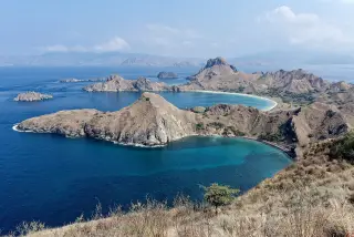
Komodo National Park waters were among the areas identified as having potential waves in the 1.25 to 2.5 metre range. That places the forecast directly within the marine area monitored by readers travelling or working around Komodo, according to the reports.
BMKG is Indonesia’s Meteorology, Climatology and Geophysical Agency. Its Tenau Kupang maritime station issued the regional warning cited in the reports.
The same forecast identified additional areas including Sabu-Raijua waters, northern and eastern NTT waters, northern Kupang-Rote waters, Pukuafu Strait and waters south of Timor-Rote. Separate higher waves of 2.5 to 3.5 metres were reported for waters south of Sumba.
The reported validity period ended at 08:00 WITA (UTC+8) on 22 September 2026. The available reports do not state a further action or extension for Komodo waters.
Sources
Read next
More on this story
Flores & Beyond
Flores Island Indonesia: where it is, how big it is and why it matters
Flores Island is eastern Indonesia’s long, mountainous gateway to Komodo, with a population of about 2 million and a 2026 earthquake that pushed it in…
Latest in Marine & Diving

Related